The first time you come over the rise on Undercliff Drive and the ground simply stops, it does not feel like Toronto. There is a lawn, a chain-link fence in poor repair, and then ninety metres of white sand cliff dropping into a lake that goes to the horizon like an ocean. No skyline, no streetcar, no condo cranes — just pale eroding rock, wind and water, twenty-five minutes from Kennedy station. The Scarborough Bluffs are the most improbable landscape inside the city limits, and the fact that most visitors to Toronto never go there is the single biggest gap in how this city gets written about.
This guide covers what the bluffs actually are, the eight or so parks along their length and which of them is worth your afternoon, how to get there with and without a car, the beach at the bottom, when to go, and the safety points that matter more here than at any other park in Toronto. Details were checked in September 2026; prices are in Canadian dollars.
At a Glance
| Detail | What to know |
|---|---|
| What it is | A shoreline cliff running roughly 15 km along Lake Ontario’s north shore |
| Height | Up to about 90 metres at the highest point |
| Where | East end of Toronto, Scarborough, from Victoria Park Avenue to East Point Park |
| Cost | Free; parking at Bluffer’s Park is paid in season |
| Nearest subway | Kennedy station, Line 2 |
| Bus to the base | Seasonal 201 Bluffer’s Park, roughly May to October |
| Best clifftop view | Cathedral Bluffs Park |
| Best beach | Bluffer’s Park Beach |
| Time needed | Half a day minimum; a full day if you want both top and bottom |
| Best season | Late September to late October for colour; July and August for swimming |
What the Bluffs Actually Are
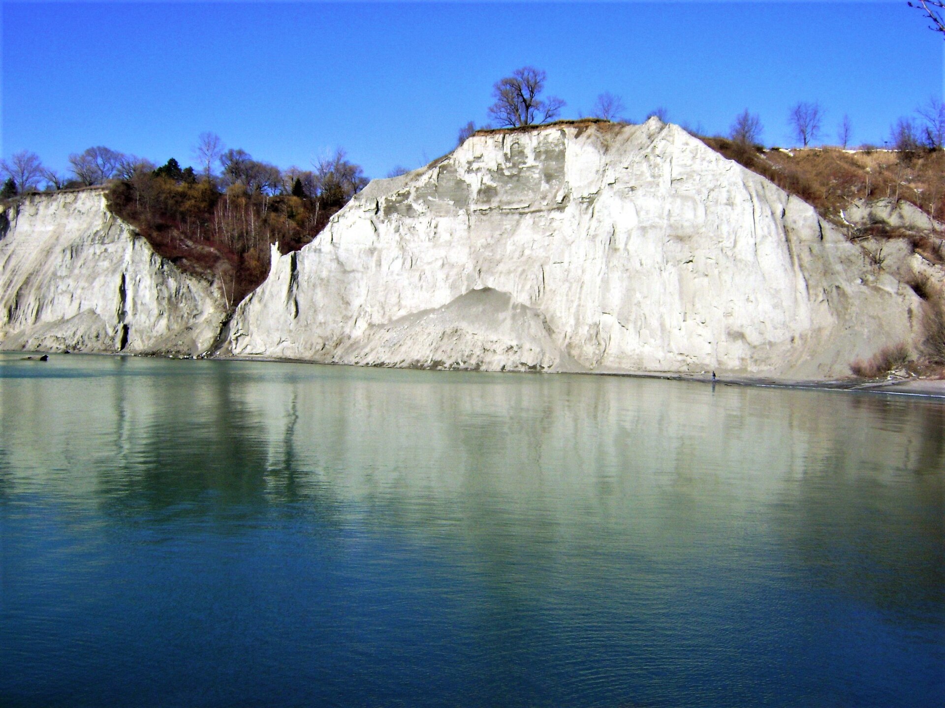
The first thing to understand is that this is not a cliff in the usual sense. There is no bedrock here. The bluffs are layers of sand, silt and clay laid down by glacial meltwater over tens of thousands of years, exposed when the lake cut into them after the last ice age. Geologists read the face like a book — the layers record a very long sequence of glacial advance and retreat, and the site has been studied since the nineteenth century for exactly that reason.
The practical consequence is that the bluffs are actively falling apart. Every heavy rain and every freeze-thaw cycle takes a little more off the top, which is why the edges are unfenced in places, fenced badly in others, and periodically closed altogether after a slope failure. The pale material you are standing on at the top is the same material sliding down the face; it is not stable and it does not announce itself before it goes.
The name comes from Elizabeth Simcoe, wife of the first lieutenant-governor of Upper Canada, who saw the cliffs from a boat in 1793 and was reminded of the cliffs at Scarborough in Yorkshire. The town, and eventually the whole eastern third of Toronto, took the name from them.
The Parks Along the Bluffs
The bluffs are not one destination but a string of small parks along fifteen kilometres of clifftop, plus one park at the bottom. They are not connected by a continuous clifftop trail, which is the thing most first-time visitors get wrong — you cannot walk the whole length along the edge, and you will need to move between them by road.
Bluffer’s Park and Bluffer’s Park Beach
The only place you can drive to the bottom, at the foot of Brimley Road South. It has a proper sand beach, a marina full of boats, a restaurant, washrooms in season and the single best view of the cliff face from below. This is where the photographs of turquoise water beneath white cliffs come from.
It is also, in July and August, extremely busy. The parking lot fills by mid-morning on a hot weekend and the road down is single-carriageway with nowhere to turn around, so a queue at the top means a genuinely long wait. The park itself is built on landfill placed to protect the toe of the bluffs from erosion, which is why the shoreline here is a series of engineered headlands rather than a natural beach.
Cathedral Bluffs Park
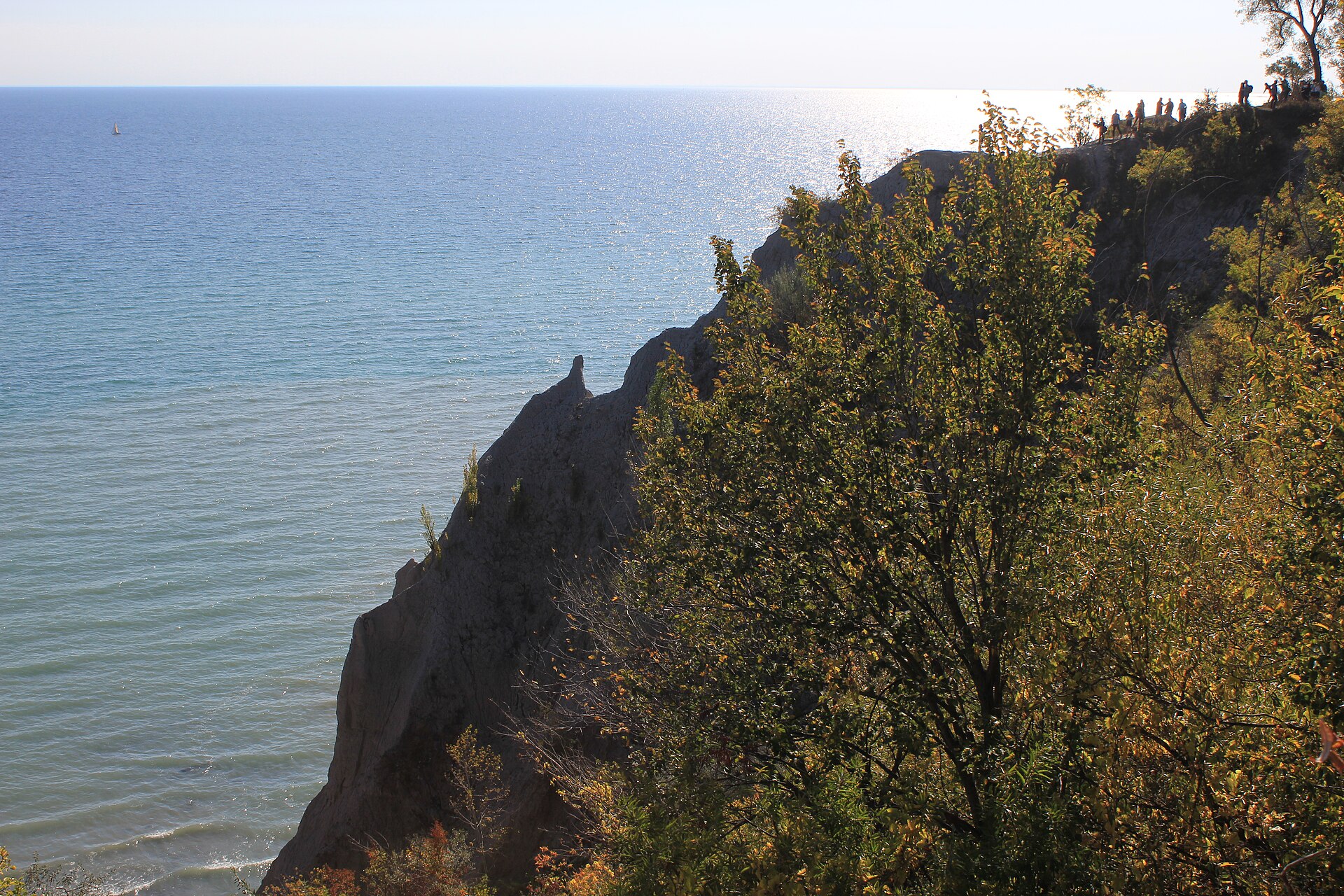
The clifftop park at the highest, most dramatic point, where erosion has cut the face into a row of pinnacles and buttresses that gave the area its ecclesiastical name. The view along the shoreline from here is the best on the bluffs. It is a small neighbourhood park with limited street parking and no facilities — come for twenty minutes and the photograph, not for a picnic.
Scarborough Bluffs Park
On Undercliff Drive, with a broad grass area running to the edge and a view straight down to Bluffer’s Park below. Easier to reach than Cathedral Bluffs, more room to sit, and the most popular clifftop spot as a result.
Rosetta McClain Gardens
A formal garden on the clifftop off Kingston Road: rose beds, a scent garden, mature trees and paved level paths, with lake views over the edge. It is the most accessible park on the bluffs by some distance and the only one that works well for visitors who cannot manage rough ground. Check the signage on arrival, as some parks along this stretch restrict dogs.
Guild Park and Gardens
The strangest and best of them. Guild Park sits on the clifftop at Guildwood and is scattered with architectural fragments rescued from demolished Toronto buildings — bank columns, carved facades, an entire Greek-style colonnade standing in the grass above the lake. It began as an artists’ colony in the 1930s and the collection was assembled as the city tore down its Victorian and Edwardian downtown through the 1950s and 60s. Give it an hour. It is on our list of Toronto hidden gems for good reason.
The Doris McCarthy Trail
The one place you can walk from the top of the bluffs to the shoreline on a proper path. It descends from Ravine Drive through a wooded ravine to the water’s edge, and takes about twenty minutes down and rather longer back up. The trail is named for the painter Doris McCarthy, who lived above it for decades at a property she called Fool’s Paradise. Wear real shoes; the surface is uneven and turns to clay soup after rain.
East Point Park
The eastern end of the bluffs, and the quietest. Open meadow, scrubby woodland and a genuinely good birding site — it sits on a migration route and the local naturalists are there most mornings in spring and autumn. Not scenic in the postcard sense; excellent if you want to be alone.
Getting There
By public transport
The base of the bluffs is served seasonally by the 201 Bluffer’s Park bus, which runs from Kennedy station on Line 2 east along Eglinton Avenue East, south down Brimley Road and into the park itself, dropping you inside rather than at the top of the hill. It operates roughly from early May to early October.
Two warnings. First, this route used to be numbered 175, and a great many articles and even some legacy transit pages still say so — if you are searching a trip planner, use 201. Second, it is seasonal, so outside the summer months there is no bus to the bottom and you will be walking down Brimley Road, which is steep and has no pavement for part of its length.
For the clifftop parks, take the 12 Kingston Road bus east and walk south, or use Line 2 to Warden or Kennedy and connect. Guild Park is easiest of all by rail: Guildwood station on the Lakeshore East GO line is a fifteen-minute walk away. Our TTC guide covers the network and the getting around Toronto guide compares the options.
By car
About forty minutes from downtown outside rush hour, considerably more in it. Brimley Road South is the only vehicle access to the beach; there is paid parking at the bottom and it fills early on summer weekends. The clifftop parks rely on residential street parking, which is signed and enforced, and the neighbourhoods have understandably lost patience with visitors blocking driveways.
The best trick, if you are coming in summer: drive to Kennedy station, park free, and take the 201 down. It removes the entire parking problem for the price of a fare.
By bike
Doable but hilly, and the route out from downtown along Kingston Road is not pleasant cycling. The better ride is east along the waterfront to the Beaches and then up — see our bike share guide for what is available and where the docks stop.
The Beach
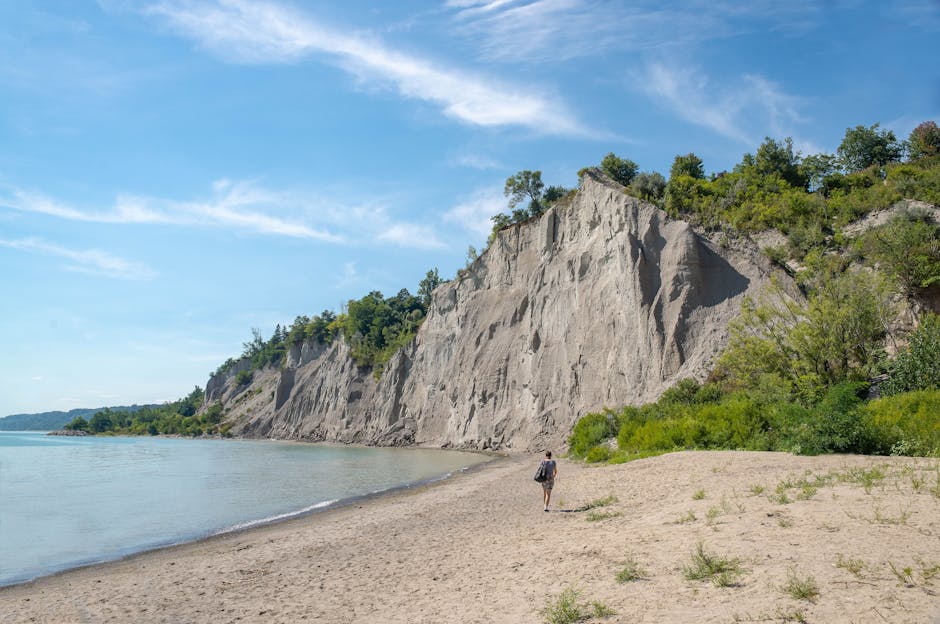
Bluffer’s Park Beach is a supervised city beach in summer, with lifeguards, washrooms and a sandy stretch under the cliff face. Water quality is monitored and posted daily; like all Toronto beaches it can be flagged after heavy rain, so check before you swim.
What makes it worth the journey rather than going to a closer beach is the setting. There is nowhere else in the city where you can swim with a ninety-metre white cliff behind you. It is meaningfully colder than the eastern Beaches because of how the currents run, it gets loud with boats from the marina, and it is worth arriving before eleven on a hot day. Our Toronto beaches guide ranks it against the alternatives.
Safety: The Part That Matters
Toronto Fire and the marine unit rescue people from these cliffs every year, and it is entirely avoidable. The house rule on this site is to say the awkward thing plainly, so:
- Do not stand on the edge. The material is unconsolidated sand and clay. It overhangs in places, it undercuts invisibly from below, and it gives way without warning. The photograph is not worth it, and the people you can see doing it in every picture of the bluffs are the reason the fences keep getting rebuilt.
- Do not climb the face. It is not rock and it will not hold. Every year somebody attempts it and requires a helicopter.
- Do not walk the shoreline at the base beyond the maintained park. There is no path, sections are impassable at high water, and material falls from above.
- Obey closure signs. Sections of clifftop are fenced off after slope failures, and the fence is there because the ground behind it has already moved.
- Keep children and dogs on the inland side. There is no barrier at several of the viewpoints.
- Watch the weather. Wind coming off the lake at the top of a ninety-metre cliff is significantly stronger than the forecast for downtown suggests.
When to Go
| Season | What it’s like | Verdict |
|---|---|---|
| Spring (Apr–May) | Green returning, muddy trails, few people | Good; the Doris McCarthy Trail is at its worst underfoot |
| Summer (Jun–Aug) | Beach open, bus running, car park full by 10am | Go for the swimming, arrive early |
| Autumn (Sept–Oct) | Colour along the clifftop, clear light, warm lake | The best time, comfortably |
| Winter (Nov–Mar) | Ice formations, no bus, bleak and beautiful | Spectacular and genuinely hazardous underfoot |
Late September into the second half of October is the answer. The trees along the clifftop turn, the light off the lake is at its clearest, the summer crowds have gone and the water is still warm enough to put your feet in. Our Toronto in fall guide covers the season across the city, and things to do in Toronto in October has the rest of that month.
Winter is extraordinary — spray freezes on the shoreline rocks and the white cliff against a grey lake is one of the great Toronto sights — but the clifftop paths ice over, the bus is not running, and it is not a casual outing.
A Half-Day and a Full-Day Plan
Half a day, no car
- 10:00 — Line 2 to Kennedy station.
- 10:30 — The 201 bus down to Bluffer’s Park.
- 10:45 — Walk the shoreline path in the park, then along to the beach for the classic view up at the cliff face.
- 12:00 — Lunch at the restaurant in the park, or a picnic on the beach.
- 13:30 — Bus back up, then the 12 Kingston Road bus west to Rosetta McClain Gardens for the clifftop view and level paths.
- 15:00 — Back to Line 2 and downtown by mid-afternoon.
A full day with a car
- 9:00 — Guild Park and Gardens first, before anyone else is there. An hour among the salvaged architecture.
- 10:30 — East along Kingston Road to East Point Park for the meadow and the birding.
- 11:30 — Back west to Cathedral Bluffs Park and Scarborough Bluffs Park for the clifftop views.
- 12:30 — Down Brimley Road to Bluffer’s Park for lunch and the beach.
- 15:00 — The Doris McCarthy Trail from Ravine Drive if your legs are willing, or Rosetta McClain Gardens if they are not.
- 17:00 — Drive west along Kingston Road into the Beaches for dinner — see our Leslieville and the Beaches guide.
Wildlife and What Grows There
The bluffs are more interesting ecologically than they look from a car park, largely because the instability that makes them dangerous also keeps them from being tidied.
The face itself supports bank swallows, which nest in colonies of burrows drilled into the exposed sand — a species that has declined steeply across Canada and for which eroding lakeshore bluffs are prime habitat. You can see the holes from the beach in early summer, and the birds hunting insects along the face. The shoreline below the cliffs holds gulls, cormorants and, through winter, large rafts of ducks; trumpeter swans, once extirpated from Ontario and reintroduced from the 1980s onward, now turn up along this stretch of shoreline regularly.
East Point Park is the birding destination proper. It sits on a migration corridor, and the mix of meadow, scrub and shoreline draws warblers in May and raptors in September. Bring binoculars and expect to meet people who have been coming every week for thirty years.
On the clifftop, the vegetation is a scruffy mix of cottonwood, sumac, dogwood and whatever has colonised recently disturbed ground — which is why the autumn colour along the edge is so good. The slope faces are largely bare, because anything that establishes on them eventually goes over with the sand.
Scarborough Itself
A word about the place, because the bluffs sit inside a part of Toronto that visitors are quietly steered away from and should not be.
Scarborough spent decades as the punchline in a certain kind of Toronto joke, and the reputation has outlived the reality by a wide margin. It is now one of the most genuinely diverse municipalities in North America and, as a direct consequence, the best place to eat in the city if what you want is food cooked by people for their own community rather than for a review. The stretches along Lawrence Avenue East, Ellesmere and Kingston Road hold Sri Lankan, Tamil, Filipino, Hakka Chinese, Caribbean and Afghan cooking of a standard that downtown does not match at any price.
If you are already out here for the cliffs, budget an hour for lunch somewhere that has no website. Our multicultural food guide covers where the city’s neighbourhood cooking actually is, and cheap eats in Toronto has more of the same. It turns a scenic half-day into a properly good one, and it is the single best argument for coming out here with a car.
What Is Not Worth It
- Coming for one park. The journey is forty minutes each way; a single twenty-minute viewpoint does not repay it. Combine at least three stops.
- Driving down to Bluffer’s Park on a July weekend after 10am. You will queue on a road with no turning space and may not get in at all.
- Expecting a continuous clifftop trail. There isn’t one. The parks are separate and you move between them on residential streets.
- The bluffs in heavy rain. The views vanish, the trails become clay, and the clifftop is at its least stable.
- Trying to reach the base anywhere except Bluffer’s Park. There is no legitimate shoreline route and the attempts are how people end up needing rescuing.
- Relying on the seasonal bus outside its season. Between October and May, no 201, and the walk down Brimley is unpleasant and partly without pavement.
Practical Tips
- Bring water and food. Beyond the restaurant at Bluffer’s Park there is essentially nothing at any of these parks.
- Washrooms are seasonal and concentrated at Bluffer’s Park. The clifftop parks mostly have none.
- Wear proper shoes. Every route worth taking is on grass, sand or clay.
- Best light is late afternoon, when the sun comes round to face the cliffs. Sunrise over the lake is spectacular but you will be photographing into it.
- Cellphone signal is fine, but note that the bottom of the ravine on the Doris McCarthy Trail is a dead spot in places.
- It is free. All of it, except parking — one of the better entries in our free things to do in Toronto guide.
- Combine with the Rouge. If you are out this way with a car and a whole day, Rouge National Urban Park is twenty minutes further east and is the other great Toronto landscape nobody visits.
Frequently Asked Questions
How do you get to the Scarborough Bluffs from downtown Toronto?
Take Line 2 east to Kennedy station, then the seasonal 201 Bluffer’s Park bus, which runs from roughly early May to early October and drops you inside the park at the base of the cliffs. By car it is about forty minutes outside rush hour, with paid parking at Bluffer’s Park via Brimley Road South.
Is there a bus to Bluffer’s Park?
Yes — the 201 Bluffer’s Park, seasonally. Note that this route was formerly numbered 175 and a lot of older information still says so. Outside the season there is no bus down the hill.
How tall are the Scarborough Bluffs?
Up to about 90 metres at the highest point, near Cathedral Bluffs, and they run roughly 15 kilometres along the Lake Ontario shoreline through the east end of Toronto.
Can you swim at the Scarborough Bluffs?
Yes, at Bluffer’s Park Beach, which is supervised in summer with lifeguards and washrooms. Water quality is tested and posted daily and can be flagged after heavy rain, so check before going in. The water is noticeably colder than at the eastern Beaches.
Is it free to visit?
Yes. All the parks along the bluffs are free; the only cost is parking at Bluffer’s Park in season.
Which viewpoint is the best?
Cathedral Bluffs Park for the most dramatic clifftop view along the shoreline, Scarborough Bluffs Park on Undercliff Drive for more space and an easier approach, and the beach at Bluffer’s Park for the view up at the cliff face. If you can only do one, do the beach — the view from below is the photograph you have seen.
Is it safe to walk along the edge?
No. The bluffs are unconsolidated sand and clay that erodes constantly, overhangs in places and collapses without warning. Stay well back from unfenced edges, do not climb the face, and respect closure signs.
How long do you need there?
Half a day for the beach and one or two clifftop parks. A full day if you want to include Guild Park, East Point and the Doris McCarthy Trail — the parks are spread over fifteen kilometres and you cannot walk between them along the top.
What is Guild Park?
A clifftop park at Guildwood scattered with architectural fragments salvaged from demolished Toronto buildings — columns, carved facades and a full colonnade standing in parkland above the lake. It began as an artists’ colony in the 1930s and is one of the strangest and best places in the city.
Are the bluffs good with children?
The beach at Bluffer’s Park is excellent with children. The clifftop parks require constant supervision because several viewpoints have no barrier at all. Our Toronto with kids guide has the safer outdoor options.
When is the best time of year to visit?
Late September through October for autumn colour, clear light and thin crowds, or July and August if you want to swim. Winter is spectacular and genuinely hazardous underfoot, with no seasonal bus running.
Related Toronto Guides
- Toronto Outdoor Activities — the pillar guide to getting outside in the city.
- Toronto Beaches — every swimmable beach in the city, ranked.
- Hiking Trails in Toronto — the ravines, the Don Valley and the Doris McCarthy Trail in context.
- Best Parks in Toronto — where the bluffs parks sit against High Park and the rest.
- Toronto Hidden Gems — Guild Park and the rest of the city’s underappreciated corners.
- Rouge National Urban Park — the other great east-end landscape.
- Toronto in Fall — when the clifftop is at its best.
Photo Credits
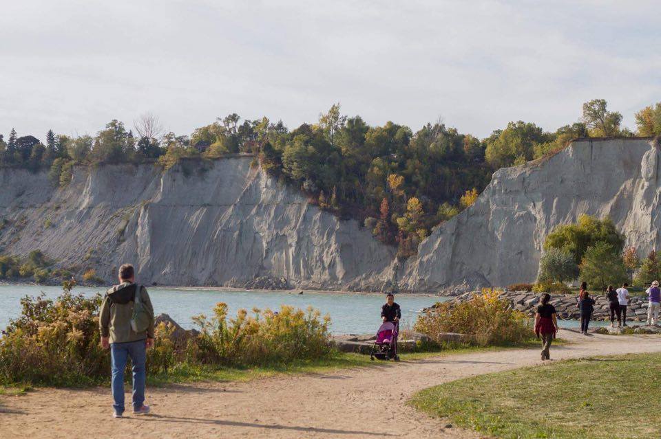
The bluffs and shoreline path in autumn: Scarborough Bluffs – Laslovarga (11) by Laslovarga, CC BY-SA 4.0, via Wikimedia Commons.
The cliff face from the water: Bluffers Park-Scarborough Bluffs- Scarborough-Ontario (1) by Mhsheikholeslami, CC BY-SA 4.0, via Wikimedia Commons.
The clifftop edge above Lake Ontario: Scarborough Bluffs – Laslovarga (27) by Laslovarga, CC BY-SA 4.0, via Wikimedia Commons.