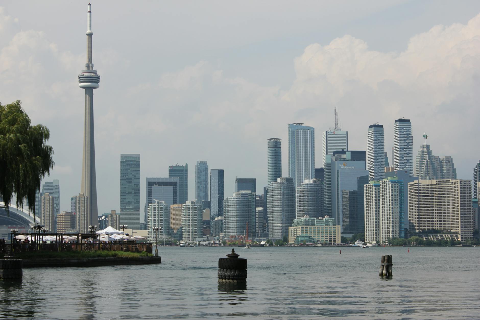
The Toronto waterfront runs along the north shore of Lake Ontario from Humber Bay in the west to the Beaches in the east, anchored by the Martin Goodman Trail (the multi-use path that follows the shore across the city) and the cluster of Harbourfront attractions just south of the CN Tower. From the Toronto Islands ferry terminal, Trillium Park’s sculptural rock outcrops, the Music Garden designed by cellist Yo-Yo Ma, the Sugar Beach pink umbrellas, and Cherry Beach’s wide swimming sands, the Toronto waterfront folds attractions, recreation, and skyline views into a single connected route. What follows is a 2026 walk through it — the attractions worth your time, the walking and cycling routes that string them together, and the practical answers most visitors end up needing. The lakefront is only one slice of the city, so it pairs naturally with the wider list of everything worth doing in Toronto.
For the official City of Toronto Martin Goodman Trail map and route, see the City of Toronto Martin Goodman Trail page.
Toronto Waterfront: The Martin Goodman Trail
The Martin Goodman Trail runs about 56 km along the Toronto waterfront, from the Humber Bay Arch Bridge in the west to the Rouge River in the east. It’s a multi-use trail open to walkers, cyclists, rollerbladers, and skateboarders, and in winter the city’s snow-clearing crews cover multi-use trails as well as bike lanes. The trail is mostly flat, paved, and segregated from car traffic.
Major access points include Humber Bay Bridge, Sir Casimir Gzowski Park, High Park, Ontario Place, Coronation Park, Harbourfront at Queen’s Quay West, Cherry Beach, Tommy Thompson Park, Ashbridge’s Bay Park, and the Eastern Beaches.
Toronto Waterfront: Central Harbourfront Attractions
Harbourfront Centre
Toronto waterfront cultural anchor at 235 Queens Quay West. A 10-acre cultural campus with live performances, art galleries, craft studios, free outdoor concerts, restaurants, and rotating festivals year-round. One of Toronto’s most distinctive cultural institutions.
Jack Layton Ferry Terminal
Gateway to the Toronto Islands. The ferry ride to Centre Island, Hanlan’s Point, or Ward’s Island is one of Toronto’s essential experiences. See our Toronto Islands guide.
HTO Park
The urban beach on the Toronto waterfront. A patch of imported sand, lakefront views, and shaded picnic spots a short walk from Union Station.
Toronto Music Garden
Designed by cellist Yo-Yo Ma and landscape architect Julie Moir Messervy, the Music Garden interprets Bach’s First Suite for Unaccompanied Cello as six garden “rooms” representing the suite’s six movements. Free guided audio tours; free Thursday and Sunday summer concerts.
Trillium Park
The 7.5-acre Toronto waterfront park has sculptural rock outcrops, native plantings, and wide views back to the city skyline. Adjacent to Ontario Place; free to access.
Simcoe WaveDeck
The wooden boardwalk just west of Simcoe Street on Queens Quay, its curves inspired by the undulating shorelines of Ontario’s Great Lakes. One of three Toronto waterfront WaveDecks (Simcoe, Spadina, Rees).
Sherbourne Common & Sugar Beach
Two of the eastern Toronto waterfront’s most distinctive small parks. Sugar Beach features the iconic pink umbrellas; Sherbourne Common has a public art installation that doubles as a stormwater treatment system.
Toronto Waterfront: Western Stretch
Ontario Place
The former 1971 theme park is being redeveloped, and access is restricted: Trillium Park stays open as public waterfront green space with beautiful lake views, while other parts of the site are closed during the work. Check Ontario Place’s site-access page before you go. Major redevelopment ongoing through the late 2020s.
Coronation Park
Large Toronto waterfront park with sports fields, a marina, and views toward Ontario Place.
Sir Casimir Gzowski Park & Humber Bay Bridge
Western Toronto waterfront park with the famous arched Humber Bay Bridge offering some of the most-photographed lakefront views west of downtown.
Sunnyside Beach
Western Toronto waterfront beach with a long sandy strip and summer swimming. Quieter than the central Harbourfront and eastern Beaches.
High Park Access
The Martin Goodman Trail runs along Lake Ontario just south of High Park, one of Toronto’s largest parks (161 hectares). Famous for cherry blossoms each spring.

Toronto Waterfront: Eastern Stretch
Cherry Beach
The Toronto waterfront favourite of locals. Cherry Beach offers wide sand and skyline views. See our hidden gems guide.
Polson Pier
The unmarked pier in the Port Lands offering Toronto’s photographer-favourite skyline view. Right next to Cherry Beach.
Tommy Thompson Park
The Leslie Street Spit, reaching out into Lake Ontario. One of Toronto’s most distinctive urban-wilderness parks: car-free trails, bird sanctuary status, and dramatic lake-and-skyline views. Check the Toronto and Region Conservation Authority’s Tommy Thompson Park page for opening days and hours before you go.
Ashbridge’s Bay Park
Eastern Toronto waterfront park with marina, sports fields, and beach access.
The Beaches Boardwalk
The wood-plank boardwalk running along the lakefront in the Beaches. Eastern terminus of the Toronto waterfront experience. See our Leslieville and The Beaches guide.
R.C. Harris Filtration Plant
The Art Deco “Palace of Purification” on the eastern Beaches lakefront. One of Toronto’s most architecturally stunning industrial buildings. See our hidden gems guide.
Toronto Waterfront: Activities
Walking & Running
At about 56 km, the full Martin Goodman Trail is a lot to take on in one go. Pick a section to match the time you have: central Harbourfront, Ontario Place to Sunnyside, or Cherry Beach to the Beaches.
Cycling
The trail is one of Toronto’s best urban cycling experiences. Bike Share Toronto stations along the entire route make rentals easy. The whole trail is about 56 km, so choose a stretch that fits your afternoon.
Kayaking, Canoeing & Paddleboarding
Harbourfront Canoe & Kayak Centre rents single and tandem kayaks, canoes, and stand-up paddleboards adjacent to HTO Park. Sunset paddles toward the Toronto Islands are unforgettable.
Beach Days
Cherry Beach (central), Sunnyside (west), and the Beaches (east) all have lifeguarded swimming in summer. Part of Hanlan’s Point Beach on the Toronto Islands is clothing-optional.
Boating & Sailing
Multiple Toronto waterfront marinas operate boat charters. Tall Ship Kajama (a 1930s three-masted schooner) offers afternoon and evening sails from Harbourfront. Mariposa Cruises operates dinner and brunch cruises.
Festivals & Events
Toronto Harbourfront Centre hosts year-round festivals including the Tirgan Iranian Festival, Hot & Spicy Festival (BBQ), Italian Contemporary Film Festival, Pan-American Food Festival, and dozens of cultural celebrations.
Toronto Waterfront: Where to Eat & Drink
Boxcar Social Harbourfront
Specialty coffee, cocktails, and waterfront views. One of the best Toronto waterfront cafes.
Amsterdam BrewHouse
Massive Toronto waterfront restaurant and brewery. Strong patio with skyline views. Best for groups.
Against the Grain Urban Tavern
Toronto waterfront pub with extensive patio and skyline views.
Cluny Bistro at the Distillery
French-Canadian fine dining in the Distillery District, east of central Harbourfront. See our Distillery District guide.
Beach Cafes & Snacks
Several seasonal Toronto waterfront cafes operate at HTO Park, Sugar Beach, Cherry Beach, and the Beaches boardwalk. Most close in winter.
Toronto Waterfront: Best Time to Visit
Late Spring through Early Autumn
May through October is when the Toronto waterfront is most alive. Patios open, ferries run on full schedule, and beach days pull crowds.
Summer Festivals (June–August)
Harbourfront Centre’s festival calendar peaks in summer. Free outdoor programming most weekends.
Sunset Walks
Late afternoon through sunset is the most photogenic time. Polson Pier, Sugar Beach, and the Toronto Islands ferry deck all catch beautiful evening light.
Winter Walks
The Martin Goodman Trail is maintained year-round. Winter walks along Sunnyside or the eastern Beaches are quieter and offer dramatic frozen-lake views.
Toronto Waterfront: How to Get There
By Streetcar
The 509 Harbourfront streetcar runs along Queen’s Quay (the heart of the Toronto waterfront) between Union Station and Exhibition Loop. The 510 Spadina comes down Spadina Avenue from Spadina Station and follows Queen’s Quay West to Union Station. Check the TTC for diversions before you set out. The 504 King streetcar runs parallel just north.
By Subway
Union Station (Yonge-University Line 1) is a short walk north of central Harbourfront, or you can ride the 509 or 510 streetcar from Union down to Queen’s Quay.
By Walking
The CN Tower, St. Lawrence Market and the Distillery District are all within walking distance. From any of them, head south to the lake and follow the water to the Harbourfront cluster.
By Bike
Bike Share Toronto stations along the entire Martin Goodman Trail.
By Car
Multiple paid parking lots ring the Toronto waterfront. Most expensive at central Harbourfront; more affordable at Cherry Beach and the eastern Beaches.
Toronto Waterfront: Walking Tour
A perfect central Toronto waterfront walking tour:
Start at Union Station: Walk south through the SkyWalk.
HTO Park: Urban beach, lakefront views, photo stop.
Toronto Music Garden: Audio-guided self-tour of Yo-Yo Ma’s six garden rooms.
Lunch at Boxcar Social Harbourfront or Amsterdam BrewHouse.
Jack Layton Ferry Terminal: Take the ferry to the Toronto Islands for skyline views.
Return for sunset: Walk Polson Pier or watch the sunset from Trillium Park.

Toronto Waterfront: What’s Nearby
CN Tower & Ripley’s Aquarium
Just north of Harbourfront. See our CN Tower guide and Ripley’s Aquarium guide.
Toronto Islands
Ferries leave from Jack Layton Terminal at the foot of Bay Street. See our Toronto Islands guide.
Distillery District
East of Harbourfront. See our Distillery District guide.
St. Lawrence Market
North-east of central Harbourfront. See our St. Lawrence Market guide.
Frequently Asked Questions: Toronto Waterfront
Where is Toronto’s waterfront?
The Toronto waterfront follows Lake Ontario from Humber Bay in the west to the Beaches in the east. The central Harbourfront cluster is just south of the CN Tower.
What is the Martin Goodman Trail?
The Martin Goodman Trail is Toronto’s waterfront multi-use trail, running about 56 km from the Humber Bay Arch Bridge to the Rouge River. Walkers and cyclists share it, and Toronto clears snow from its multi-use trails in winter.
How long is the Toronto waterfront walking trail?
The full Martin Goodman Trail is about 56 km. Rather than planning the whole route, pick a section that fits your time, on foot or by bike.
What is HTO Park?
HTO Park is the urban Toronto waterfront beach, with a sandy lawn and lakefront views, just south of the CN Tower at Queen’s Quay.
What is Sugar Beach?
Sugar Beach is the eastern Toronto waterfront park with iconic pink umbrellas. Just east of Sherbourne Common and west of the Distillery District.
Can you swim at Toronto’s waterfront?
Yes — multiple lifeguarded swimming beaches operate in summer including Cherry Beach, Sunnyside Beach, the Beaches, and the Toronto Islands beaches. The boardwalk at HTO Park is for sunbathing rather than swimming.
How do I get to the Toronto waterfront?
The 509 Harbourfront and 510 Spadina streetcars both run along Queen’s Quay, the heart of the Toronto waterfront, and both serve Union Station, which sits a short walk north of central Harbourfront.
Is the Toronto waterfront family-friendly?
Yes — the Toronto waterfront is one of the most family-friendly parts of the city. HTO Park, Sugar Beach, the Music Garden, and the Toronto Islands ferry all welcome kids.
Where can I rent kayaks on the Toronto waterfront?
Harbourfront Canoe & Kayak Centre rents single and tandem kayaks, canoes, and stand-up paddleboards adjacent to HTO Park.
When is the best time to visit the Toronto waterfront?
Late May through early October. Summer festivals at Harbourfront Centre, full ferry service to the islands, and patio season all peak from June through August.
Almost everything that floats commercially in this city leaves from the slips between York Street and Lower Spadina, and the docks look confusingly alike once you are standing among them. If you are trying to work out which boat is worth boarding — the hour-long sightseeing run, the tall ship, the dinner cruise or none of them — our guide to Toronto harbour cruises and boat tours lays out the prices, the seasons and the honest verdict on each.
Plan Your Toronto Waterfront Visit
The Toronto waterfront rewards visitors who treat it as a connected experience rather than individual stops. Walk or bike a section of the Martin Goodman Trail, ferry to the Toronto Islands, eat lunch at a Harbourfront cafe, and watch the sunset from Polson Pier or Trillium Park — you’ll have experienced the version of Toronto that locals love most. For first-time visitors, a half-day at central Harbourfront combined with a Toronto Islands ferry trip delivers the iconic Toronto waterfront experience.
From Jack Layton Ferry Terminal it is a short ride across the harbour to the Toronto Islands, and the lakefront leads east toward Leslieville and the Beaches or the cobblestones of the Distillery District — or you can fold the lake into a broader plan of things to do in Toronto. The waterfront is one of many districts covered in our Toronto neighborhoods guide.