Getting Around Toronto: Your Complete Transportation Guide
Toronto is one of Canada’s most accessible cities, with a comprehensive and efficient transportation network that makes exploring the vibrant urban landscape incredibly convenient. Whether you’re arriving at Pearson Airport, navigating downtown neighborhoods, or venturing into the Greater Toronto Area, you’ll find multiple reliable options to get around. From the iconic red streetcars to modern subway trains, extensive bus networks, and innovative bike-sharing programs, Toronto’s transportation system is designed to keep you moving smoothly through the city.
The best part? Once you understand how the system works, getting around Toronto becomes effortless. In this comprehensive guide, we’ll walk you through every transportation option available to tourists, from the TTC (Toronto Transit Commission) networks to airport connections, water ferries, and pedestrian pathways. By the end, you’ll feel confident navigating the city like a local.
TTC Subway System: Toronto’s Rapid Transit Backbone
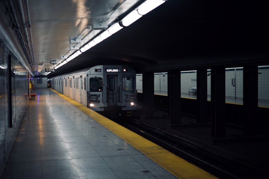
The Toronto Transit Commission (TTC) operates the city’s subway system, which is the fastest way to travel long distances. With four main lines crisscrossing the city, the subway serves millions of passengers annually and is the cornerstone of Toronto’s public transportation network.
The Four Subway Lines
Line 1 (Yonge-University): This is Toronto’s primary subway line, forming a U-shape through the city. Running from Kipling Station in the west, up University Avenue through downtown, then along Yonge Street to Bloor and beyond, Line 1 connects many major attractions including Toronto’s entertainment district, cultural institutions, and shopping areas.
Line 2 (Bloor-Danforth): Running east-west across the city along Bloor Street, this line provides access to Yonge-Dundas Square, major retail areas, and the Scarborough neighborhood. It’s an excellent route for exploring Toronto’s diverse communities and cultural neighborhoods.
Line 3 (Scarborough): Note that this light rail line has been undergoing significant changes. The Scarborough RT line operated for decades but services have been affected by ongoing transit modernization projects. Check current status before planning your trip to Scarborough.
Line 4 (Sheppard): The Sheppard line runs east-west in the north-central part of Toronto, serving the Sheppard Avenue corridor. While shorter than other lines, it’s a convenient option for reaching neighborhoods like North York and provides connections to other transit lines.
Subway Hours and Frequency
The TTC subway operates during the following hours:
- Weekdays (Monday-Friday): 6:00 AM – 1:30 AM
- Saturdays: 6:00 AM – 1:30 AM
- Sundays: 8:00 AM – 1:30 AM
- Train Frequency: Trains arrive every 2-6 minutes during peak hours, and every 5-10 minutes during off-peak times
This frequency makes the subway an extremely reliable option—you’ll rarely wait more than 10 minutes for a train, and during busy periods, trains come constantly. The predictable schedule and regular service make it easy to plan your visit without worrying about missing connections.
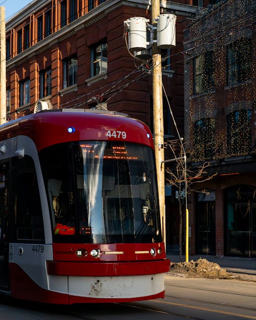
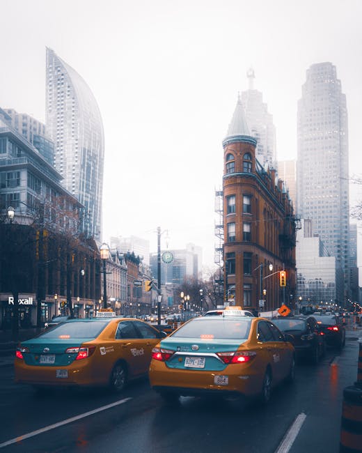
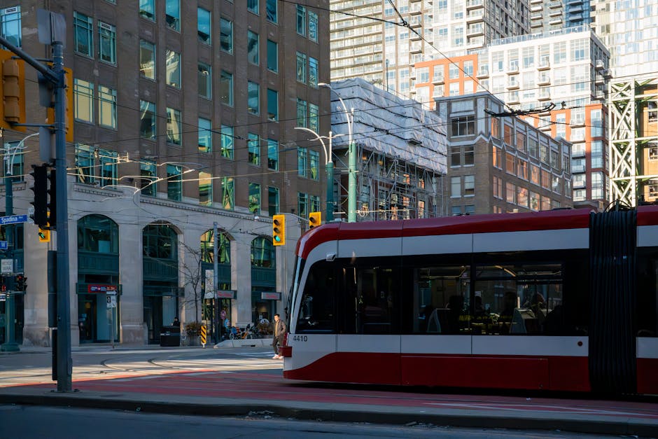
TTC Streetcars: Toronto’s Iconic Vehicles
If there’s one Toronto transportation icon that defines the city’s character, it’s the red streetcar. These historic vehicles have been part of Toronto’s landscape for over a century, and riding them is not just practical—it’s an essential Toronto experience. The streetcar network operates 11 routes throughout the city, with several key lines running through downtown and residential neighborhoods.
Key Streetcar Routes
King Street Line: Runs east-west through downtown, passing historic neighborhoods, restaurants, bars, and entertainment venues. Perfect for exploring Toronto’s heritage district and vibrant downtown core.
Queen Street Line: Another iconic downtown route, Queen Street is known for its eclectic shopping, galleries, and cultural institutions. Riding this line gives you a genuine feel for Toronto’s creative neighborhoods.
Dundas Line: Connecting multiple neighborhoods, the Dundas streetcar line is excellent for reaching shopping districts and cultural attractions.
Spadina Line: Running north-south, Spadina connects downtown with neighborhoods like Chinatown and Little Italy. It’s a great way to experience Toronto’s multicultural character.
Modern Flexity Streetcars
Toronto has been modernizing its streetcar fleet with new Flexity vehicles, which are sleek, quiet, and more comfortable than their vintage counterparts. These modern streetcars have improved seating, better climate control, and enhanced accessibility features while maintaining the charm and character that makes Toronto’s streetcar system unique. You might notice a mix of older and newer vehicles on the same routes—both are authentic Toronto experiences.
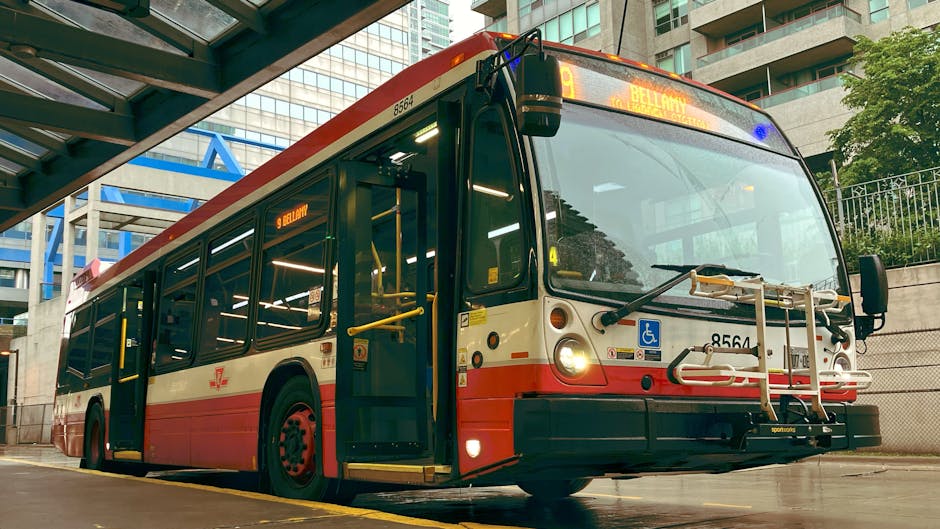
TTC Buses: Comprehensive Neighborhood Coverage
While the subway and streetcars are glamorous, buses form the backbone of Toronto’s public transportation system. TTC buses reach neighborhoods that subway doesn’t serve, providing essential connectivity throughout the city and Greater Toronto Area. With hundreds of routes and extended hours, buses ensure that no corner of Toronto is inaccessible.
Regular Bus Service
The TTC operates regular bus service during typical transit hours (approximately 5 AM to 1 AM), with routes serving every neighborhood in Toronto. Bus frequency varies from every 5 minutes on busy routes to every 15-20 minutes on less-traveled routes. Most major routes are quite frequent, making buses a reliable transit option for getting around the city.
Blue Night Network: Late-Night Service
For travelers with late nights, Toronto’s Blue Night Network provides extended bus service after regular hours. Operating between 1:30 AM and 5:00 AM, this dedicated night bus service ensures you can get home after enjoying Toronto’s nightlife. Night bus routes follow major downtown streets and key neighborhood connectors, making it convenient to reach your accommodation no matter how late you’re out.
PRESTO Card: Your Gateway to Toronto Transit
The PRESTO card is the most convenient way to pay for TTC transit in Toronto. This smart card system works across all Toronto transit modes—subway, streetcar, and bus—and even works on GO Transit throughout the Greater Toronto Area. For tourists, getting a PRESTO card is an excellent investment that will streamline your transit experience.
Getting Your PRESTO Card
You have two options for accessing PRESTO:
- Physical PRESTO Card: $4 CAD for the card itself (one-time purchase). Available at participating retailers including Shoppers Drug Mart, subway stations, and transit customer service locations.
- Digital PRESTO Wallet: Free to use on your smartphone via the PRESTO app or mobile wallet. Download the app, set up your account, and start using it immediately with no physical card needed.
PRESTO Fares
Single Adult Fare: $3.35 CAD per trip on TTC. This covers a single journey on any combination of subway, streetcar, or bus within a continuous two-hour period.
Two-Hour Transfer Window: Once you tap your PRESTO card, you get a two-hour window to transfer between transit modes as many times as needed at no additional cost. This is ideal if you’re combining multiple transit types during your journey.
NEW for 2026: Fare Capping Program
Toronto has introduced an innovative fare capping system that protects frequent travelers. Once you’ve made 47 rides in a calendar month using PRESTO, all additional rides for the rest of that month are free. This effectively caps your monthly cost at $156 (47 × $3.35), matching the price of a monthly pass. This is excellent news for tourists planning extended stays—after about two weeks of daily transit use, you’ll start enjoying free rides for the remainder of your visit.
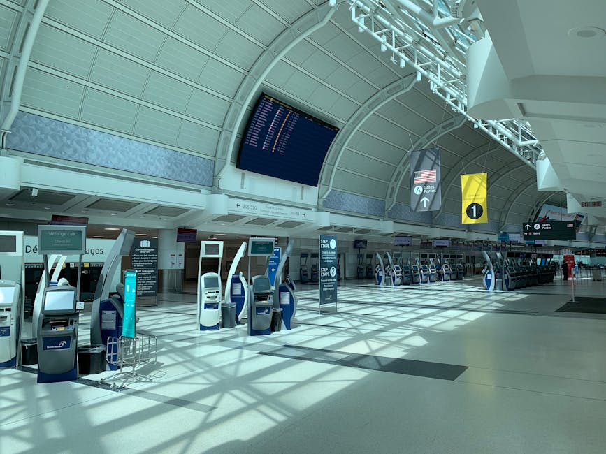
UP Express: Fast Connection to Pearson Airport
One of Toronto’s best transit innovations, the UP Express (Union Pearson Express) provides a lightning-fast connection between Pearson International Airport and downtown Toronto. For arriving and departing passengers, this is the ideal way to connect to the rest of the city.
Journey Details
- Route: Toronto Pearson International Airport (Terminal 1) to Union Station in downtown Toronto
- Travel Time: Just 25 minutes end-to-end
- Frequency: Trains depart every 15 minutes throughout the day and evening
- Availability: First train 5:27 AM, last train around midnight
UP Express Fares
- Adult Single Fare: $12.35 CAD
- PRESTO Card Fare: $9.25 CAD (25% discount)
The UP Express is more expensive than regular TTC transit, but the speed and convenience—especially when arriving with luggage—makes it well worth the cost. From the moment you arrive at the airport to stepping onto the subway at Union Station takes less than 30 minutes.
Toronto Pearson Airport Connections: Getting to Downtown
Toronto Pearson International Airport is Canada’s largest airport and serves as the main gateway for tourists visiting Toronto. Several transportation options connect the airport to downtown Toronto, each with different costs and journey times.
Your Options
- UP Express (Union Pearson Express): Fastest option at 25 minutes, costs $12.35 or $9.25 with PRESTO. Recommended for most travelers.
- TTC Bus 192 (Airport Rocket): Budget-friendly option at $3.35 with PRESTO, takes 30-40 minutes but makes many stops. Good if you’re not in a hurry.
- TTC Bus 52: An alternative bus route, takes longer but follows a different path through the city.
- Taxi: White taxis available at the ground transportation level. Fixed fare of approximately $55-65 to downtown Toronto, depending on destination.
- Uber/Lyft Rideshare: Available via the Uber and Lyft apps. Surge pricing may apply during peak hours. Costs vary based on demand.
GO Transit: Exploring the Greater Toronto Area
GO Transit is the regional transit system serving the Greater Toronto Area and beyond. While primarily focused on commuters, GO Transit offers tourists access to destinations outside Toronto proper, including Niagara Falls and other regional attractions.
GO Transit Services
Trains and Buses: GO Transit operates a network of regional trains and buses connecting Toronto to surrounding communities. If you’re exploring Niagara Falls, cottage country, or other GTA destinations, GO Transit provides affordable connections.
Niagara Seasonal Service: During peak tourist season, GO Transit operates seasonal bus and train services to Niagara Falls, making it easy to visit this world-famous attraction without renting a car.
Your PRESTO card also works on GO Transit, though GO Transit fares are separate from TTC fares and vary based on distance traveled.
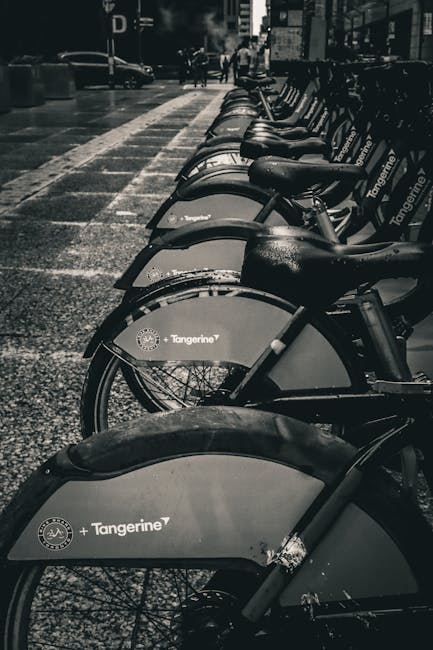
Cycling in Toronto: Bike Share and Beyond
Toronto is increasingly becoming a bike-friendly city, with extensive cycling infrastructure making two-wheeled travel both practical and enjoyable. For tourists without access to a personal bicycle, Bike Share Toronto offers an excellent solution.
Bike Share Toronto
- Network Size: 9,000+ bicycles available at 800+ stations throughout the city
- Coverage: Stations located throughout downtown and major neighborhoods, making it easy to find a bike nearby
- Pricing: Single-ride passes available, or multi-day tourist passes for extended cycling adventures
- Operation: Bikes are available 24/7, making it convenient to cycle whenever it suits your schedule
Cycling Infrastructure
Dedicated Bike Lanes: Toronto has invested heavily in protected bike lanes throughout the city, creating safe routes separated from car traffic. These dedicated lanes make cycling much more accessible and enjoyable, even for tourists unfamiliar with the city.
Toronto Waterfront Trail: One of North America’s most scenic cycling routes, the Toronto Waterfront Trail stretches for miles along the lake, offering beautiful views and a relatively flat, easy ride. It’s perfect for casual cycling and provides a different perspective on the city.
Walking in Toronto: The Pedestrian-Friendly City
Don’t underestimate the value of getting around Toronto on foot. The downtown core is remarkably compact and walkable, with neighborhoods like St. Lawrence, the Distillery District, and Kensington Market best explored at a pedestrian pace. Walking allows you to discover hidden gems, pop into local shops, and truly experience the city’s vibrant street life.
Walkable Neighborhoods
Downtown Toronto is extremely walkable, with most major attractions within a 2-3 mile radius. Neighborhoods like the Distillery District offer pedestrian-only streets lined with galleries, restaurants, and shops. Kensington Market is a maze of narrow streets perfect for walking exploration. Queen West, King West, and Yonge Street all offer excellent walking experiences with retail, dining, and cultural attractions.
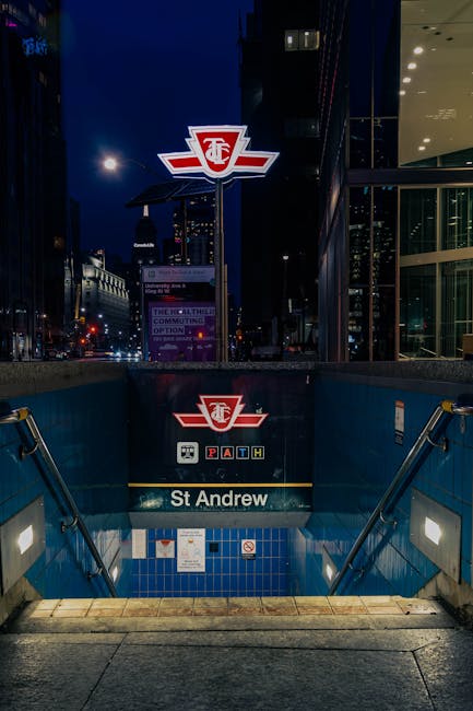
The PATH: Toronto’s Underground Walkway Network
One of Toronto’s most unique features is the PATH, an underground walkway system that’s particularly invaluable during harsh winter weather. This network of interconnected passages spans approximately 30 kilometers and connects over 75 buildings in downtown Toronto, including office towers, shopping centers, hotels, and subway stations.
The PATH allows you to navigate significant portions of downtown Toronto entirely indoors, which is essential knowledge during Toronto’s cold, snowy winters. In summer and fall, it provides a fascinating alternative to street-level walking. PATH connections link to major transit hubs, shopping areas, and hospitality venues, making it an essential resource for winter visits or for exploring downtown in any weather.

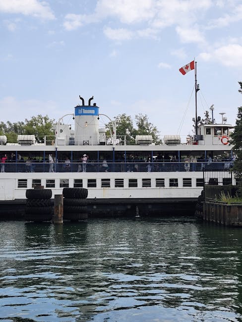
Water Transportation: Toronto’s Island Ferries
Toronto’s waterfront location offers unique transportation opportunities via water. The Toronto Island Ferry service provides both practical transportation and a delightful sightseeing experience.
Toronto Island Ferry
Departure Point: Ferry service departs from Jack Layton Terminal (formerly Toronto City Dock) at the foot of Bay Street, right at the harbour front in downtown Toronto.
Destinations: The ferry serves Toronto Islands, which offer parks, beaches, and recreational facilities. The islands are a peaceful escape from the city hustle and provide beautiful views of Toronto’s skyline.
Journey Time: Ferry rides to the islands take 5-15 minutes depending on your destination. The ferries themselves offer beautiful views of the harbour and are as much an attraction as the islands themselves.
Water Taxis
For a more upscale water-based transportation experience, private water taxi services operate in Toronto’s harbour, offering scenic routes and flexible scheduling compared to public ferries.
Taxis and Rideshare: On-Demand Transportation
For times when public transit isn’t convenient or when you want maximum flexibility, Toronto offers abundant options for on-demand transportation.
Taxis
- Availability: Yellow taxis can be hailed on the street or at taxi stands found at hotels, the airport, major attractions, and transit stations
- Pricing: Metered fares; typical rides within downtown run $15-25, with airport transfers around $55-65
- Advantages: No app needed, regulated pricing, drivers familiar with the city
Rideshare Services (Uber and Lyft)
- Availability: Both services operate in Toronto and can be booked through their mobile apps
- Pricing: Varies based on demand; surge pricing applies during peak hours
- Advantages: Cashless payment, upfront pricing (usually), ability to track your driver
For most trips, public transit is more economical, but taxis and rideshare offer convenience when you need flexibility or have luggage/mobility limitations.
Accessible Transportation in Toronto
Toronto is committed to accessible transportation for all visitors. Several services and accessibility features ensure that travelers with mobility limitations can navigate the city confidently.
TTC Accessibility
- Accessible Subway Stations: Many (though not all) subway stations have elevators, making them accessible for wheelchairs and strollers
- Tactile Guidance: Subway platforms include tactile warning strips for visually impaired passengers
- Accessible Buses and Streetcars: Modern buses and streetcars have ramps and designated spaces for wheelchair users
Wheel-Trans Service
Toronto’s Wheel-Trans is a specialized paratransit service for people with disabilities who cannot use regular TTC services. The service operates throughout the city with accessible vehicles and trained staff, ensuring that everyone can access Toronto’s attractions regardless of mobility limitations.
Renting a Car in Toronto (And Why You Might Not Need To)
While car rentals are available at Toronto Pearson Airport and downtown locations, most tourists don’t need a car to explore Toronto. The public transit system is so comprehensive and the downtown core is so walkable that a rental car often adds unnecessary cost and complexity—especially when dealing with parking in expensive downtown lots.
However, if you’re planning to venture significantly beyond Toronto (like Niagara Falls, Muskoka, or other Ontario destinations) or prefer the independence of personal transportation, rental cars are readily available from major providers.
Practical Tips for Getting Around Toronto
Essential Tips for Tourists
- Get PRESTO at the Airport: Purchase or activate your PRESTO card immediately upon arrival. With the digital wallet option, you can start using transit within minutes of landing.
- Use Google Maps for Transit Routing: Google Maps has excellent integration with TTC schedules and will provide turn-by-turn directions using public transit, showing real-time arrival times.
- Plan Around Rush Hours: Avoid traveling during peak transit hours if you want a more comfortable experience. Rush hours are typically 7:30-9:30 AM and 4:30-6:30 PM on weekdays. Mid-day and evening transit is much more relaxed.
- Take a Streetcar Ride: At least once, take a streetcar just for the experience. It’s quintessentially Toronto and surprisingly fun.
- Download the TTC App: The official TTC app provides real-time transit information, service alerts, and route planning.
- Explore Neighborhoods on Foot: While transit is efficient for long distances, walking through Toronto’s diverse neighborhoods is where you’ll discover the city’s true character.
- Know Your Payment Options: While PRESTO is convenient, some tourists prefer the simplicity of day passes or multi-day passes for uninterrupted access without worrying about card balances.
Explore More Toronto Transportation Guides
- Toronto TTC Guide: Subway, Streetcar & Bus for Tourists
- Airport to Downtown Toronto: Transportation Options & Guide
- PRESTO Card Guide: How to Use Toronto’s Transit Payment System
- UP Express: The Fast Track from Pearson Airport to Union Station
- Renting a Car in Toronto: Everything You Need to Know
- Bike Share Toronto: Cycling Your Way Through the City
- Walking Toronto: The PATH, Neighborhoods & Pedestrian Routes
Official Resources
For additional information about Toronto transportation:
- TTC Official Website (ttc.ca) – Complete information about subway, streetcar, and bus services
- PRESTO Card Official Site (prestocard.ca) – Information about PRESTO payment system and fare information
Leave a Reply